In India’s ever-evolving urban and rural landscapes, infrastructure resilience is increasingly critical—whether it’s for earthquake vulnerability assessment, post-disaster recovery, routine civic maintenance, or more equitable tax assessments. Recognizing this, the Drone-based Infrastructure Assessment Project, a collaboration between IHub-Data at IIIT Hyderabad and the Robotics Research Centre, IIIT Hyderabad is pioneering new methods to collect, process, and release high-quality datasets that can power the next generation of AI-based infrastructure assessment systems.
These datasets are now publicly available through india-data.org, an open research data platform operated by IHub-Data, under the National Mission on Interdisciplinary Cyber-Physical Systems (NM-ICPS) supported by the Department of Science and Technology, Government of India.
The Problem We’re Solving
In most Indian municipalities, infrastructure health monitoring is still largely manual and reactive. Post-disaster assessments—whether after a flood, cyclone, or building collapse—are often delayed and lack spatial precision. Similarly, property tax evaluations rely on outdated or incomplete records.
By deploying drones with high-resolution cameras and AI-ready pipelines, our project introduces a scalable solution to document building conditions, structural anomalies, and land use patterns with greater speed and accuracy. The goal: create standardized, annotated datasets that help automate damage detection and enable more data-driven governance.
How We’re Building the Dataset
The current datasets have been curated from field surveys conducted in collaboration with few organizations in Telangana and CSIR-CBRI. These surveys include drone flights over semi-urban and rural settlements, capturing building facades, rooftops, and terrain at high resolution. The drone imagery is then processed using in-house photogrammetry and vision-based pipelines to generate:
- Orthomosaics – Seamlessly stitched plan and elevation views of surveyed buildings
- 3D Point Clouds – Dense reconstructions of building volumes and elevations
- Annotated Frames – Image segments labelled for visible damage types (e.g., cracks, wall collapse, roof degradation)
- Geospatial Metadata – GPS coordinates, flight logs, and camera calibration details for downstream spatial analysis
The project also incorporates field insights by working closely with local stakeholders and domain experts. Their on-ground understanding helps guide annotation efforts and ensures that data reflects region-specific building typologies and damage indicators.
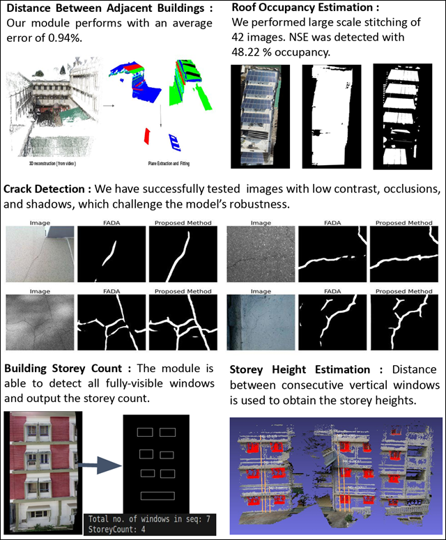
Sample applications of the Drone Based Infrastructure Assessment Datasets
Open Access, Responsible Use
All processed datasets are freely available for research and non-commercial use through india-data.org, IHub-Data’s open repository designed to support AI and data science R&D in the Indian context.
For commercial use, licensing options are available. We are open to collaborating with industry partners, civic tech startups, and solution developers looking to integrate these datasets into products or services. Interested parties can reach out to IHub-Data via the contact form on the portal or directly at dfsupport@india-data.org.
By making these resources openly available while ensuring responsible usage, we aim to foster a vibrant ecosystem of innovation in AI for infrastructure, drone autonomy, disaster response, and urban planning.
What’s Next?
Looking ahead, the project will expand to additional regions across India, capturing a broader diversity of built environments—from coastal villages to dense city blocks. Upcoming releases will include time-series datasets for pre- and post-event analysis, and multilingual survey metadata for better integration with administrative workflows.
If you’re working on AI for infrastructure, urban tech, or drone-based mapping, we invite you to explore the datasets on india-data.org and reach out with collaborations or use-cases. Every pixel tells a story—and with your help, we can make those stories count.
To explore and learn more about drone-based infrastructure R&D
Please visit:
https://uvrsabi-instructions.readthedocs.io/en/latest/index.html
https://civil-inspection-project-docs.readthedocs.io/en/latest/modules.html
Author
Prof. Harikumar Kandath – Assistant Professor, Ph.D (IISc Bangalore)
Email: harikumar.k@iiit.ac.in
Website URL: Prof. Harikumar Kandath
Publisher
Sangita Rathod, IHUB-Data
LinkedIn URL: Sangita Rathod